Developing a high-res geospatial imagery platform
Article By : Paul Tetley, Mark Trotman, Nick Perkins
Designers combined satellite and airborne imagery using NI's PXI Express and FlexRIO to master the control and measurement of a cost-effective, high-resolution, wide area geospatial image acquisition system.
Geospatial imagery from satellites and airborne platforms provides the feedstock for a remarkably wide range of commercial, government and social applications. These range from management of high-profile, international scale humanitarian and disaster relief programmes, to everyday commercial applications that impact us all, often without us even being aware of it. As an example of this latter category, in many countries the business of installing renewable-energy photovoltaics to residential and commercial buildings relies exclusively on geospatial imagery to provide an efficient, non-intrusive commercial estimating service.
Current technologies for capturing geospatial imagery are a commercial compromise. Satellites can capture geospatial imagery across entire continents, but at the expense of spatial resolution and the flexibility to image specific areas according to a custom, on-demand timetable. Existing aerial solutions can capture high resolution imagery on demand, but are cost-prohibitive for repetitive, large-area application.
Australian company Spookfish Innovations developed an airborne platform that produces cost-effective, high-resolution, wide-area geospatial imagery on demand, delivering the best features of both satellite and existing aerial solutions from a single airborne platform.
Spookfish engaged NI Alliance partner ICON Technologies to provide the system integration framework for the camera systems that enable their technology vision.
System integrates proprietary, COTS components
The Spookfish Airborne Imaging Platform is an integration of proprietary components and commercial-off-the-shelf devices that achieves a combination of image capture rate, imaging geometry, data redundancy and resolution that has not been previously possible. It requires that multiple cameras be precisely steered in continuous synchronised motion, with associated recording of camera pointing angles, platform orientation and acceleration for use in post-processing. At normal operating altitudes and speeds this requires that the cameras be steered with milli-degree precision, and that logged data about camera angles and platform position must provide near-microsecond accuracy.
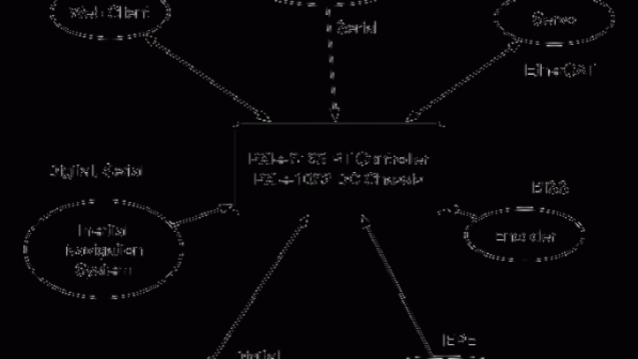
The National Instruments PXI Express platform provides the framework for timing and synchronising all the system components, and acts as master controller for all major system functions.

*Figure 1: Schematic shows the major external devices and associated communications protocols.*
The PXIe master system comprises a PXIe-1082DC Chassis, PXIe-8135RT Controller, PXI-6683H GPS/PPS Synchronisation Module, PXIe-6674T Timing Module, PXIe-7971R FlexRIO FPGA Module and PXIe-4464 Accelerometer Module.
Continue reading on EDN Asia »

Subscribe to Newsletter
Test Qr code text s ss